


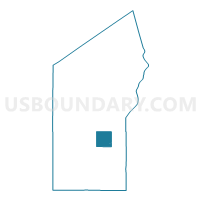
MASON - T 1 Voting District, Bayfield County, Wisconsin
About
Outline

Summary
| Unique Area Identifier | 692356 |
| Name | MASON - T 1 Voting District |
| County | Bayfield County |
| State | Wisconsin |
| Area (square miles) | 35.92 |
| Land Area (square miles) | 35.92 |
| Water Area (square miles) | 0.00 |
| % of Land Area | 100.00 |
| % of Water Area | 0.00 |
| Latitude of the Internal Point | 46.45865350 |
| Longtitude of the Internal Point | -91.11427840 |
Maps

Graphs
Select a template below for downloading or customizing gragh for MASON - T 1 Voting District, Bayfield County, Wisconsin


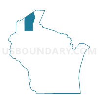
Neighbors
Neighoring Voting District (by Name) Neighboring Voting District on the Map
- DELTA - T 1 Voting District, Bayfield County, WI
- DRUMMOND - T 1 Voting District, Bayfield County, WI
- EILEEN - T 1 Voting District, Bayfield County, WI
- GRANDVIEW - T 1 Voting District, Bayfield County, WI
- KELLY - T 1 Voting District, Bayfield County, WI
- KEYSTONE - T 1 Voting District, Bayfield County, WI
- Mason - V 1 Voting District, Bayfield County, WI
Top 10 Neighboring County Subdivision (by Population) Neighboring County Subdivision on the Map
- Eileen town, Bayfield County, WI (681)
- Grandview town, Bayfield County, WI (468)
- Kelly town, Bayfield County, WI (463)
- Drummond town, Bayfield County, WI (463)
- Keystone town, Bayfield County, WI (378)
- Mason town, Bayfield County, WI (315)
- Delta town, Bayfield County, WI (273)
- Mason village, Bayfield County, WI (93)